


Vasai : Sea Beaches Fisher Man (Koli) Life
From the Camera of Great Photographerno1
www. Photographerno1.com


Panchu Bandar vasai


Vasai Forte Beach


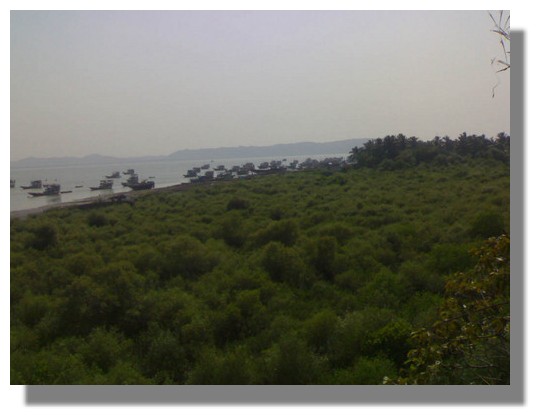
Panachoo Bander Vasai


Dry Fish

Picnic Spots Of Vasai

Location: -Vasai Fort,
Address:-Vasai Koliwada
Parnaka,Vasai Gaon
Tourist Spot

Vasai Forte Map


Location: Vajreshwari,
Address: Mumbai-Ahmedabad Highway
Vasai Road(East)
Devotees Spot

Location: Kalam Beach
Address:Nirmal Gaon
Kalam,Vasai(West)
Picnic Spot

Location: Rajodi Beach
AddressNirmal Gaon
RajodiNaka,Vasai(West)
Picnic Spot

Location:Rangoan Beach
AddressRangaon Village
NirmalNaka,Vasai(West)
Picnic Spot

Location:Tungareshwar Water Fall
Mumbai-Ahmedabad Highway
Sativali,Vasai(East)
Tourist Spot

Location:Chinchoti Water Fall
AddressMumbai-Ahmedabad Highway
Tiwri,Naigaon(East)
Picnic Spot
Arnala Beach

Buses from Virar railway station will bring you to Arnala a (short distance of 25 mins). From the Arnala market you will have to traverse through the small fishing village of Arnala to reach the sea shores. From here its only the small trawlers that can carry you to the Fort Island.
Arnala Fort is located approximately 8 miles North of Vasai. It is built on a small island off the Arnala port. Since the fort is built on an island and surrounded on all sides by water it is also known as “Jaldurg” or “Janjire Arnala” Portuguese called the island “Ilha das vocas”. Before the Portuguese control of the island, the island was controlled by the Muslim rulers of Gujarat.
The island is near the mouth of Vaitarna river and the Portuguese used it to observe and control shipping and navigation along the western coast. The Portuguese captain of Bassein donated the island to a Portuguese nobleman. The nobleman tore down the old fort and began construction of 700 foot by 700 foot fort. The fort was never completed by the nobleman but remained under Portuguese control.
Jivdani Temple

The most significant landmark in Virar is the Jivdani temple located on the mountain (“Jivdani Doanger”) visible from the railway station.
Many people of Vasai especially – Mangayle, Koli and Bhandhari treat Javdani as their family goddess. The devotees return the “Navas” or blessing/favor by sacrificing goats and chickens. They also offer gold ornaments.
Devotees believe that to return to have “Navas” granted they must climb the mountain and worship the goddess but not return the same way as they climbed the mountain.
Gorai Beach


Gorai beach is a prisitine and isolated beach.Nearby is the famous Esselworld Amusement park.The beach is accessible by crossing the Gorai creek by steamer.After crossing the creek the beach is just 4 kms away.The nearest station is Borivli and is also accessible from the road off Western express Highway via Bhayander.
How to Reach?
From Borivli station go to Gorai khadi Then by steamer and then By Bus and From Bhayander Station By Bus.
—————————————–
About Us
![]()

www.evasai.com
Welcome to the Vasai info homepage. We are currently making all efforts to make this sitemore beautiful and more user friendly for the people in and from vasai.Start Your Morning with Evasai.com and stay for latest information.
Vasai, in all senses of the word is a city and yet is more than a city.
Web: www.evasai.com; Finance Blog: www.vasaimoney.blogspot .com
While our efforts continue to make this site as pleasant as possible for the readers. we would like to thankall the people who have been visiting here and are spreading the news out there.
Your Feedback are valuable for us.Contact Us Evasai.com is a local community portal and hence targeted locally. Features like Daily Updated Local News Events, Vital Info,Help lines and Local Yellow Pages have made it a popular site for the Local information seekers.
-
Vasai panvel Daily Train Memu
-
Vasai Wealth Maxmiser Guidence
-
Vasai Hospitanls and Doctors
-
GYM around Vasai
-
Vasai Business Directory
-
Vasai Bus Services
-
Emergency Numbers Of Vasai
-
Vasai Train Service Local and Express
-
Vasai Tourism
![]() This is a online business cum e-commerce directory of Mumbai and suburb Vasai, listing local specific businesses. Searching on Business Directory is very easy. One can choose from the search box or use links at the bottom of the page. The region of Vasai-Virar is known as Vasai taluka a part of Thane district in Maharashtra.Geographically it is situated between East 72.480 to 72.540 Latitudes and North 19.240 to 19.280.Longtitudes. Vasai is located about 50-km North of Mumbai. Vasai starts from river Ulhas on theSouth and ends with Vaitarna river in the North. On the Eastern side is Tungareshwar, Vajreshwari, the hilly tracks of Wada and Bhiwandi towns and on the West is theArabian sea. Thus Vasai combines climates of mountain tracks, shore-land,humidity and heavy rains. Its average rainfall is 80 inches. The Hindu Puranas suggest that the sixth incarnation of Vishnu, Parshurama createdthe Konkan region. The Vasai-Virar region comprises the north Konkan region.During the ancient times it was known as Sopara, and is talked about in the Skand Puranas.The kingdom of Sopara is also referred in the Mahabharata. Pandu’s son Sahadevaannexed this region to there Hastinapur empire during the Rajasui Yagna of Yudhistira.Vasai has two small sea ports, one at Arnala in the north and the second at Vasai in the south. And access from anywhere, anytime. HOW TO PLACE ADVERTISEMENT Targeted Display and Classified advertisement packages are also available.You can avail this opportunity for a very nominal cost as a Introductory offer. Contact us.
This is a online business cum e-commerce directory of Mumbai and suburb Vasai, listing local specific businesses. Searching on Business Directory is very easy. One can choose from the search box or use links at the bottom of the page. The region of Vasai-Virar is known as Vasai taluka a part of Thane district in Maharashtra.Geographically it is situated between East 72.480 to 72.540 Latitudes and North 19.240 to 19.280.Longtitudes. Vasai is located about 50-km North of Mumbai. Vasai starts from river Ulhas on theSouth and ends with Vaitarna river in the North. On the Eastern side is Tungareshwar, Vajreshwari, the hilly tracks of Wada and Bhiwandi towns and on the West is theArabian sea. Thus Vasai combines climates of mountain tracks, shore-land,humidity and heavy rains. Its average rainfall is 80 inches. The Hindu Puranas suggest that the sixth incarnation of Vishnu, Parshurama createdthe Konkan region. The Vasai-Virar region comprises the north Konkan region.During the ancient times it was known as Sopara, and is talked about in the Skand Puranas.The kingdom of Sopara is also referred in the Mahabharata. Pandu’s son Sahadevaannexed this region to there Hastinapur empire during the Rajasui Yagna of Yudhistira.Vasai has two small sea ports, one at Arnala in the north and the second at Vasai in the south. And access from anywhere, anytime. HOW TO PLACE ADVERTISEMENT Targeted Display and Classified advertisement packages are also available.You can avail this opportunity for a very nominal cost as a Introductory offer. Contact us.
 Matrimonials
- 32 yrs, Male, 5'8", Hindu, Garhwali, Garhwali, India
- 30 yrs, Male, 5'11", Hindu, Garhwali, Brahmin - Garhwali, India
- 39 yrs, Male, 5'8", Hindu, Garhwali, Rajput, India
- 29 yrs, Male, 5'9", Hindu, Sourashtra, Sourashtra, India
- 25 yrs, Male, 5'5", Hindu, Magahi, Brahmin - Bhumihar, India
- 55 yrs, Male, 5'9", Christian, English, Born Again, Australia
- 34 yrs, Male, 6'0", Hindu, Bhojpuri, Brahmin - Bhumihar, India
- 47 yrs, Male, 5'6", Christian, English, Roman Catholic, India
- 24 yrs, Male, 5'3", Hindu, Bihari, Pasi, India
- 36 yrs, Male, 5'4", Hindu, Sourashtra, Sourashtra, India
Recent Comments
rita patil on Banks In Vasai pankaj on Local Train Time Table Morgan on Child abuse cases in city on t… Thankappan on Loan Documents for Flats Bijal on The pin codes of Maharash… Follow Us


